
Unnamed Road,43-382, 43-382 Bielsko-Biała, Poland
Q252+5F Bielsko-Biala, Poland
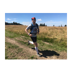
 Segmentos Strava
Los fragmentos de este vídeo son segmentos Strava verdaderos


| Pos. | Usuario | Chrono | Date |
|---|---|---|---|
| 1 | 00:21:21 | 2/25/2022 | |
| 2 | 00:22:08 | 4/29/2023 | |
| 3 | 00:29:29 | 3/2/2022 | |
| 4 | 00:29:31 | 3/1/2022 | |
| 5 | 00:30:21 | 1/22/2024 |

Puedes probar nuestra aplicación completa y gratuitamente y desafiar a los miembros de la comunidad.
iOS Android ¿Ningún acceso a Google Play? Descargar el APK ahoraAccede a todas las funciones y vídeos por solo $11.99/ mensuales
Suscríbete ahoraProbablemente te gustará...

6.214 mi | 01:04:51

4.661 mi | 00:41:02

6.224 mi | 01:01:05

5.64 mi | 00:40:00

6.164 mi | 01:08:43

5.91 mi | 00:48:29

3.786 mi | 00:43:13

4.99 mi | 00:44:08

6.841 mi | 00:47:32

4.222 mi | 00:45:42

5.741 mi | 00:57:16

6.783 mi | 00:56:53


 Francés
 Español
 Alemán
 United States
 Chino
Chino
 Italian
 Dutch
Dutch