
Glorianna Trailhead - Black Canyon Trail, Crown King Road, Yavapai County, Arizona, United States
Black Canyon Trail, Yavapai County, Arizona, United States
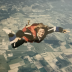
Black Canyon 100K 2025 – Part 7 (39km to 44km) | FPV Trail Running
Welcome to Part 7 of my FPV trail running footage from the Black Canyon 100K 2025! This segment covers kilometers 39 to 44, taking you from the Gloriana Mine Aid Station as you make your way toward the Deep Canyon Aid Station.
This stretch features a mix of rugged, rocky trails and sweeping desert views as you continue deeper into the heart of the Sonoran Desert.
🎥 Shot in first-person view to give you the runner’s perspective.
📍 Location: Black Canyon Trail, Arizona
🏃 Distance: 5 km (Part 7 of full 100K footage series)
🛠️ Aid Station Segment: Gloriana Mine (AS4) ➡️ Deep Canyon (AS5)
If you enjoyed the video, don’t forget to ❤️ and follow me for more trail running content and full race coverage. Thanks for watching!
 Segmentos Strava
Los fragmentos de este vídeo son segmentos Strava verdaderos


| Pos. | Usuario | Chrono | Date |
|---|---|---|---|
| 1 | 00:11:59 | 5/14/2025 | |
| 2 | 00:12:21 | 5/21/2025 | |
| 3 | 00:14:13 | 5/24/2025 | |
| 4 | 00:14:34 | 7/6/2025 | |
| 5 | 00:14:53 | 5/25/2025 |

Puedes probar nuestra aplicación completa y gratuitamente y desafiar a los miembros de la comunidad.
iOS Android ¿Ningún acceso a Google Play? Descargar el APK ahoraAccede a todas las funciones y vídeos por solo $11.99/ mensuales
Suscríbete ahoraProbablemente te gustará...

3.13 mi | 00:29:22

4.661 mi | 00:41:02

2.066 mi | 00:40:26

3.269 mi | 00:24:41

1.727 mi | 00:18:15

2.906 mi | 00:34:46

1.833 mi | 00:28:18

2.67 mi | 00:31:30

1.785 mi | 00:16:57

2.925 mi | 00:47:26

2.656 mi | 00:21:56

3.786 mi | 00:43:13


 Francés
 Español
 Alemán
 United States
 Chino
Chino
 Italian
 Dutch
Dutch