
5348 Rte de la Croisette, 74160 Collonges-sous-Salève, France
Pont routier de Pougny, ou pont routier de Chancy, Route de, 1284 Chancy
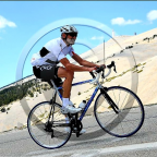
You first climb gently climb from La Croisette to the Col des Pitons. Then follows a long downhill (with a few intermediate short climbs) to the Rhone river near the village Chancy. A great exercise if you go full-out on the uphill and flat parts, and recover on the downhills. Enjoy!!
See other downhills at downhills by Gonvil
(PS: 'likes' and 'comments' on the video are much appreciated. Please send comments on the functioning of the app to the User Support)
For more than 1000 scenic videos all over Europe, see my other videos by Gonvil and Playlists by Gonvil.
 Segmentos Strava
Los fragmentos de este vídeo son segmentos Strava verdaderos


| Pos. | Usuario | Chrono | Date |
|---|---|---|---|
| 1 | 00:35:31 | 1/29/2022 | |
| 2 | 00:37:15 | 3/4/2022 | |
| 3 | 00:37:37 | 3/2/2022 | |
| 4 | 00:37:50 | 2/23/2022 | |
| 5 | 00:39:21 | 2/22/2022 |

Puedes probar nuestra aplicación completa y gratuitamente y desafiar a los miembros de la comunidad.
iOS Android ¿Ningún acceso a Google Play? Descargar el APK ahoraAccede a todas las funciones y vídeos por solo $11.99/ mensuales
Suscríbete ahoraProbablemente te gustará...

18.946 mi | 01:08:07

24.822 mi | 02:10:23

24.171 mi | 01:31:22

25.786 mi | 01:36:22

11.981 mi | 00:52:34

14.298 mi | 00:53:07

31.377 mi | 02:08:14

19.232 mi | 01:09:17

21.137 mi | 01:44:00

21.17 mi | 01:10:00

15.76 mi | 01:15:25

23.373 mi | 01:12:35


 Francés
 Español
 Alemán
 United States
 Chino
Chino
 Italian
 Dutch
Dutch