
Glorianna Trailhead - Black Canyon Trail, Crown King Road, Yavapai County, Arizona, United States
Black Canyon Trail, Yavapai County, Arizona, United States
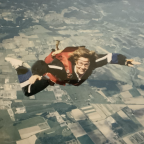
Black Canyon 100K 2025 – Part 7 (39km to 44km) | FPV Trail Running
Welcome to Part 7 of my FPV trail running footage from the Black Canyon 100K 2025! This segment covers kilometers 39 to 44, taking you from the Gloriana Mine Aid Station as you make your way toward the Deep Canyon Aid Station.
This stretch features a mix of rugged, rocky trails and sweeping desert views as you continue deeper into the heart of the Sonoran Desert.
🎥 Shot in first-person view to give you the runner’s perspective.
📍 Location: Black Canyon Trail, Arizona
🏃 Distance: 5 km (Part 7 of full 100K footage series)
🛠️ Aid Station Segment: Gloriana Mine (AS4) ➡️ Deep Canyon (AS5)
If you enjoyed the video, don’t forget to ❤️ and follow me for more trail running content and full race coverage. Thanks for watching!
 Segmenti di Strava
Porzioni di questo video sono effettivi segmenti di Strava


| Pos. | Nome utente | Chrono | Date |
|---|---|---|---|
| 1 | 00:11:59 | 5/14/2025 | |
| 2 | 00:12:21 | 5/21/2025 | |
| 3 | 00:14:13 | 5/24/2025 | |
| 4 | 00:14:34 | 7/6/2025 | |
| 5 | 00:14:53 | 5/25/2025 |

Puoi provare la nostra applicazione in modo completo e gratuito e sfidare i membri della community.
iOS Android Nessun accesso a Google Play? Scarica APK oraOttieni tutte le funzionalità e i video a soli $11.99/mese
Abbonati oraProbabilmente ti piacerà...

1.634 mi | 00:16:02

3.266 mi | 00:31:52

2.193 mi | 00:25:13

2.182 mi | 00:11:45

3.91 mi | 00:39:00

2.82 mi | 00:20:09

2.61 mi | 00:29:08

4.509 mi | 00:49:11

4.304 mi | 00:43:56

3.251 mi | 00:24:47

4.782 mi | 00:29:57

3.096 mi | 00:28:45


 Francese
 Inglese
 Tedesco
 United States
 Cinese
 Spanish
 Dutch
Dutch