
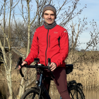
Panoche Access Road, Fresno County, California, United States
Day use parking and information area, Panoche Access Road, Fresno County, California, United States
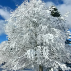
Enjoy the beauty of a Superbloom day in the Panoche Hills! But, what is a "Superbloom" and why?
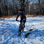
Panoche Hills Recreation Area is a low mountain range in the Southern Inner California Coast Ranges System, in western Fresno County, California. The hills are east of the Diablo Range, on the west side of the San Joaquin Valley. They define the eastern side of the Panoche Valley. If you go ride in the Panoche Hills, make sure that you stay at the Mercey Hot Springs and enjoy the hot bath!
As always, choose Discovery mode and turn the sound ON for a more realistic and immersive experience. Choose Challenge mode if you are in a racing mood.
For your maximum enjoyment, this video was recorded and Uploaded in 4K Ultra HD
 Segmenti di Strava
Porzioni di questo video sono effettivi segmenti di Strava


| Pos. | Nome utente | Chrono | Date |
|---|---|---|---|
| 1 | 00:05:45 | 5/1/2025 | |
| 2 | 00:06:08 | 4/30/2025 | |
| 3 | 00:08:09 | 5/5/2025 | |
| 4 | 00:08:47 | 4/18/2025 | |
| 5 | 00:10:01 | 4/9/2025 |

Puoi provare la nostra applicazione in modo completo e gratuito e sfidare i membri della community.
iOS Android Nessun accesso a Google Play? Scarica APK oraOttieni tutte le funzionalità e i video a soli $11.99/mese
Abbonati oraProbabilmente ti piacerà...

4.05 mi | 00:20:01

2.179 mi | 00:30:19

2.553 mi | 00:11:47

2.646 mi | 00:15:07

3.373 mi | 00:23:03

5.802 mi | 00:28:59

2.28 mi | 00:09:08

5.495 mi | 01:30:08

3.473 mi | 00:18:09

5.062 mi | 00:40:36

2.551 mi | 00:10:02

5.661 mi | 00:26:35


 Francese
 Inglese
 Tedesco
 United States
 Cinese
 Spanish
 Dutch
Dutch