
7780 College Ave, Sutter, CA 95982, USA
11709 N Butte Rd, Live Oak, CA 95953, USA
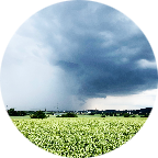
The Sutter Buttes lie 50 miles north of Sacramento, California, and are sometimes called the world’s smallest mountain range.
However, the buttes are technically not mountains, but rather volcanic hills topped by eroded domes formed 1.6 million years ago. Sutter Buttes’ highest point is 2,122 feet high, a dramatic contrast to the flat agricultural lands that stretch out past the buttes for miles. The Buttes, and the neighboring town, are named after Captain John Sutter, who received a large land grant from the Mexican government in the 19th century. Most of the land is private property used by ranchers and farmers, although in 2003 the state of California acquired 1,785 acres of the Buttes, including a section called Peace Valley. On April 8, 2005, the State Park and Recreation Commission classified the State Parks Sutter Buttes Property as a State Park.
As always, select Discovery mode and turn the sound ON for a more realistic and immersive experience. Choose Challenge mode if you are in a racing mood.
For your maximum enjoyment, this video was recorded and Uploaded in 4K Ultra HD
 Strava分段
此视频的部分是实际Strava段片


您可能会喜欢这个...

19.277 mi | 01:15:18

24.822 mi | 02:10:23

15.211 mi | 01:04:46

19.868 mi | 01:41:08

15.59 mi | 01:12:32

12.442 mi | 00:45:22

11.866 mi | 00:50:23

12.187 mi | 01:07:48

25.786 mi | 01:36:22

16.896 mi | 00:56:39

11.017 mi | 00:38:47

15.58 mi | 01:02:18


 法语
法语
 英语
英语
 德语
德语
 美国
美国
 西班牙的
西班牙的
 意大利的
意大利的
 荷兰语
荷兰语