
71 Route du Col de Cou, 74550 Cervens, France
841 Route de la Vallée du Giffre, 74250 Fillinges, France
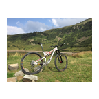
A nice sunny ride in the beautiful Chablais mountains/hills south of Thonon-les-Bains. The video starts at the 'Col de Cou' at about 1100 m altitude and finishes 550 m lower in the village Fillinges. The area is also called 'Vallee Verte (green valley)'. You will see why... Enjoy!!
(PS: 'likes' and 'comments' on the video are much appreciated. Please send comments on the functioning of the app to the User Support)
For more than 1000 scenic videos all over Europe, see my other videos by Gonvil and Playlists by Gonvil.
 Strava分段
此视频的部分是实际Strava段片


您可能会喜欢这个...

8.785 mi | 01:00:16

8.349 mi | 00:46:59

15.59 mi | 01:12:32

12.442 mi | 00:45:22

9.118 mi | 00:35:14

9.255 mi | 00:48:41

7.89 mi | 00:44:33

12.388 mi | 00:50:31

10.63 mi | 00:37:46

12.428 mi | 00:40:43

7.147 mi | 00:29:44

15.128 mi | 00:55:57


 法语
法语
 英语
英语
 德语
德语
 美国
美国
 西班牙的
西班牙的
 意大利的
意大利的
 荷兰语
荷兰语