
5348 Rte de la Croisette, 74160 Collonges-sous-Salève, France
Pont routier de Pougny, ou pont routier de Chancy, Route de, 1284 Chancy
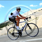
You first climb gently climb from La Croisette to the Col des Pitons. Then follows a long downhill (with a few intermediate short climbs) to the Rhone river near the village Chancy. A great exercise if you go full-out on the uphill and flat parts, and recover on the downhills. Enjoy!!
See other downhills at downhills by Gonvil
(PS: 'likes' and 'comments' on the video are much appreciated. Please send comments on the functioning of the app to the User Support)
For more than 1000 scenic videos all over Europe, see my other videos by Gonvil and Playlists by Gonvil.
 Strava分段
此视频的部分是实际Strava段片


您可能会喜欢这个...

18.946 mi | 01:08:07

24.822 mi | 02:10:23

24.171 mi | 01:31:22

25.786 mi | 01:36:22

11.981 mi | 00:52:34

14.298 mi | 00:53:07

31.377 mi | 02:08:14

19.232 mi | 01:09:17

21.137 mi | 01:44:00

21.17 mi | 01:10:00

15.76 mi | 01:15:25

23.373 mi | 01:12:35


 法语
法语
 英语
英语
 德语
德语
 美国
美国
 西班牙的
西班牙的
 意大利的
意大利的
 荷兰语
荷兰语