
N Bloomfield Rd, Nevada City, CA 95959, USA
W Point Overlook, Nevada City, CA 95959, USA
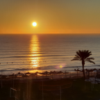
Malakoff Diggins State Historic Park is 26 miles northeast of Nevada City, California in the scenic foothills of the Sierra Nevada. The park was created in 1965 by concerned citizens to preserve the exciting and controversial story of our country’s largest hydraulic gold mining operation that devastated the area from the mid-1800s. During this walk you will see the Diggins Pond, Hiller Tunnel, various viewpoints of the area, a monitor cannon that was used to blast water on the mountain side.
Malakoff Diggins and North Bloomfield were in part established by French gold miners as described in the book "Le tour du monde, 1862" and still celebrated to this day during the French Connection Festival.
Note: The GPS was struggling with the steep hills around and lost signal a few times, including while going down to the Hiller tunnel, it will appear as you are stopped for a couple of minutes.
 Strava分段
此视频没有Strava细分
您可能会喜欢这个...

1624 yd | 00:25:59

1.199 mi | 00:20:54

1372 yd | 00:20:19

1265 yd | 00:14:35

1.379 mi | 00:26:02

1109 yd | 00:15:10

1.55 mi | 00:26:24

1.131 mi | 00:25:28

1717 yd | 00:30:14

1578 yd | 00:17:38

1.08 mi | 00:20:34

1529 yd | 00:13:52


 法语
法语
 英语
英语
 德语
德语
 美国
美国
 西班牙的
西班牙的
 意大利的
意大利的
 荷兰语
荷兰语