774 Route du Queyras, 05600 Guillestre, France
SP251, 12020 Pontechianale CN, Italy
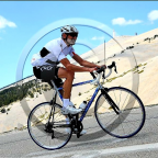
The Col Agnel (at 2744 m altitude) is the 2nd highest road col in France (just behind the Col de l'Iseran), connecting France and Italy. This video shows the entire climb from Guillestre, almost 42 km long and with 1860 m elevation gain. Excellent to do on a rainy sunday if you are super fit. Of course, Kinomap offers the possibility to resume the video if a 3 hrs climb is a bit too much in one go. The col was 4 times part of the Giro and 2 times part of the Tour de France. Good luck and enjoy!!
Interested in doing other huge climbs, see long epic climbs
For lots of videos of cols, see: Cols in France and Cols in Switzerland
(PS: 'likes' and 'comments' on the video are much appreciated. Please send comments on the functioning of the app to the User Support)
For more than 1000 scenic videos all over Europe, see my other videos by Gonvil and Playlists by Gonvil.
 Strava Segmente
Teile dieses Videos sind tatsächliche Strava-Segmente


| Pos. | Benutzername | Chrono | Date |
|---|---|---|---|
| 1 | 00:53:04 | 3/9/2024 | |
| 2 | 00:54:02 | 4/30/2021 | |
| 3 | 01:02:14 | 11/1/2024 | |
| 4 | 01:03:28 | 7/21/2021 | |
| 5 | 01:04:28 | 10/18/2021 |

Du kannst unsere App umsonst und mit all seinen Funktionen testen und andere Mitglieder herausfordern.
iOS Android Kein Zugang zum Google Play Store? Jetzt die APK herunterladenErhalte alle Funktionen und Videos für nur %Preis%/Monat
Jetzt abonnierenDas wird dir vermutlich gefallen...

24.171 mi | 01:31:22

25.786 mi | 01:36:22
![[LONG] Kielce - Bolmin - Kielce (Poland)🚴🏘️🌲⛰️](https://dtn44hfc1xtr4.cloudfront.net/z/8/z8hrj6_320x240.jpg?Expires=1757254145&Signature=SN~VJVqcgTogfC2wo3PThXnKOjYi7To~tAITfCyqRiedCq1s7a2~xGknf0D4lQSW7sgY3tFN4sc4VJZ7IV3osOffGubycLkbGcol9lOySuPmvxGSzYyJnS2yj0~wwmNRQLwEEMfNxUqM1VrgT5cjc5iHtB35hhbt48D-J~PNLPI2BS6xk8IsLO2NcXyKPgEXG-k2MUs1MLRdUtu5-lNb5vYxEu-Ivo0uK8s137tCyRMZBH-UX16iwZa4ZqZL1atN~eBgijkNkFIyjAbHp7bX2EX6KWh1Ex6JYcw-tuuVNQpltTku0IMhiHslKb0V7fzYt-~WMsj2vThWLdH-BFKodA__&Key-Pair-Id=APKAIAOH4YUSYMI7SPBA)
38.334 mi | 02:03:29

14.298 mi | 00:53:07

34.666 mi | 03:05:19

31.377 mi | 02:08:14

15.76 mi | 01:15:25

23.373 mi | 01:12:35

16.431 mi | 02:09:06

20.1 mi | 01:15:52

19.817 mi | 01:40:26

14.133 mi | 00:39:54
 Französisch
 Englisch
 United States
 Chinesisch
 Spanisch
 Italienisch
 Niederländisch