
1 Pl. du Belvedere, 01710 Thoiry, France
1 Pl. du Belvedere, 01710 Thoiry, France
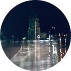
Part of the 'Route Forestiere (Forest road)' in the Pay-de-Gex in eastern France, from the Tiocan (starting point to the hike to the Reculet) to farges and back, at an altitude between 870 and 1170 m. Due to the forest trucks and the cold winters the road is in rather poor condition, but OK on a gravel bike. Enjoy!!
(PS: 'likes' and 'comments' on the video are much appreciated. Please send comments on the functioning of the app to the User Support)
For more than 1000 scenic videos all over Europe, see my other videos by Gonvil and Playlists by Gonvil.
 Strava-segmenten
Delen van deze video zijn de eigenlijk Strava-segmenten


| Pos. | Gebruikersnaam | Chrono | Date |
|---|---|---|---|
| 1 | 00:32:08 | 7/27/2021 | |
| 2 | 00:32:25 | 5/13/2021 | |
| 3 | 00:33:21 | 5/18/2021 | |
| 4 | 00:33:54 | 11/25/2020 | |
| 5 | 00:35:35 | 5/12/2021 |

U kunt onze applicatie volledig en gratis proberen en leden van de gemeenschap uitdagen.
iOS Android Geen toegang tot Google Play? Download de .apk nuKrijg toegang tot alle functies en video’s voor maar $11.99/maand
Neem nu een abonnementU zult ..... waarschijnlijk leuk vinden

8.534 mi | 00:30:45

17.063 mi | 01:08:33

15.382 mi | 01:06:02

15.741 mi | 00:59:58

12.688 mi | 00:59:54

15.062 mi | 01:08:04

13.911 mi | 00:56:13

13.968 mi | 00:52:45

12.017 mi | 00:52:53

13.164 mi | 00:58:39

16.75 mi | 00:54:49

8.334 mi | 00:37:18


 Frans
Frans
 Engels
 Duits
Duits
 United States
 Chinees
 Spanish
 Italian