
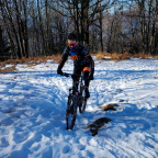
Panoche Access Road, Fresno County, California, United States
Day use parking and information area, Panoche Access Road, Fresno County, California, United States
Enjoy the beauty of a Superbloom day in the Panoche Hills! But, what is a "Superbloom" and why?
Panoche Hills Recreation Area is a low mountain range in the Southern Inner California Coast Ranges System, in western Fresno County, California. The hills are east of the Diablo Range, on the west side of the San Joaquin Valley. They define the eastern side of the Panoche Valley. If you go ride in the Panoche Hills, make sure that you stay at the Mercey Hot Springs and enjoy the hot bath!
As always, choose Discovery mode and turn the sound ON for a more realistic and immersive experience. Choose Challenge mode if you are in a racing mood.
For your maximum enjoyment, this video was recorded and Uploaded in 4K Ultra HD
 Strava-segmenten
Delen van deze video zijn de eigenlijk Strava-segmenten


| Pos. | Gebruikersnaam | Chrono | Date |
|---|---|---|---|
| 1 | 00:06:08 | 4/30/2025 | |
| 2 | 00:08:09 | 5/5/2025 | |
| 3 | 00:08:47 | 4/18/2025 | |
| 4 | 00:10:01 | 4/9/2025 | |
| 5 | 00:10:28 | 4/13/2025 |

U kunt onze applicatie volledig en gratis proberen en leden van de gemeenschap uitdagen.
iOS Android Geen toegang tot Google Play? Download de .apk nuKrijg toegang tot alle functies en video’s voor maar $11.99/maand
Neem nu een abonnementU zult ..... waarschijnlijk leuk vinden

3.651 mi | 00:17:43

5.288 mi | 00:30:20

2.553 mi | 00:11:47

2.646 mi | 00:15:07

5.819 mi | 00:46:59

5.802 mi | 00:28:59

5.67 mi | 00:27:47

3.674 mi | 00:28:17

3.343 mi | 00:21:06

5.495 mi | 01:30:08

5.21 mi | 00:25:09

3.908 mi | 00:31:04


 Frans
Frans
 Engels
 Duits
Duits
 United States
 Chinees
 Spanish
 Italian