
Chemin du Signal 4, 1185 Mont-sur-Rolle, Switzerland
Route d'Arzier 1, 1264 Saint-Cergue, Switzerland
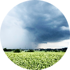
The first 8 km are a bit downhill and flat and serve as an excellent warm-up for the climb to come. Views on the Swiss Jura close to Nyon, halfway between Geneva and Lausanne. Don't forget your sun-cream: a strong low sun straight into your face. Enjoy!!
(PS: 'likes' and 'comments' on the video are much appreciated. Please send comments on the functioning of the app to the User Support)
For more than 1000 scenic videos all over Europe, see my other videos by Gonvil and Playlists by Gonvil.
 Strava segments
Portions of this video are actual Strava segments


| Pos. | Username | Chrono | Date |
|---|---|---|---|
| 1 | 00:35:36 | 3/24/2021 | |
| 2 | 00:42:51 | 4/18/2021 | |
| 3 | 00:43:19 | 4/11/2021 | |
| 4 | 00:43:42 | 3/1/2021 | |
| 5 | 00:44:07 | 9/1/2022 |

You can try our application fully and for free and challenge community members.
iOS Android No access to Google Play? Download the APK nowGet all features and videos for only $11.99/month
Subscribe nowYou will probably like...

7.622 mi | 00:39:15

10.701 mi | 00:32:42

9.614 mi | 00:23:13

7.344 mi | 00:36:14

9.491 mi | 00:35:05

8.833 mi | 00:46:45

15.97 mi | 01:05:11

10.98 mi | 00:43:28

14.141 mi | 01:05:59

7.147 mi | 00:29:44

19.092 mi | 01:10:48

15.128 mi | 00:55:57


 French
 German
 United States
 Chinese
 Spanish
 Italian
 Dutch
Dutch