
5 Rue de la Libération, 67220 Saint-Martin, France
D424, 67420 Ranrupt, France
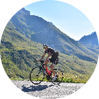
🇫🇷 A la découverte de l'Alsace Je vous emmène à la découverte d'une partie du massif Vosgien, de Villé jusqu'au Col de Steige situé à 540m d'altitude entre Champ du Feu et la montagne du Climont.
🇬🇧 Discovering Alsace I take you to discover of a part of the Vosges massif, from Villé to the Steige pass located at 540m between Champ du Feu and the Climont mountain.
 Strava segments
Portions of this video are actual Strava segments


| Pos. | Username | Chrono | Date |
|---|---|---|---|
| 1 | 00:13:40 | 5/25/2022 | |
| 2 | 00:14:18 | 3/11/2021 | |
| 3 | 00:18:15 | 11/9/2020 | |
| 4 | 00:18:50 | 11/8/2020 | |
| 5 | 00:18:58 | 1/13/2021 |

You can try our application fully and for free and challenge community members.
iOS Android No access to Google Play? Download the APK nowGet all features and videos for only $11.99/month
Subscribe nowYou will probably like...

9.255 mi | 00:48:41

7.89 mi | 00:44:33

7.147 mi | 00:29:44

5.892 mi | 00:24:01

7.665 mi | 00:45:19

9.218 mi | 00:35:00

4.05 mi | 00:20:01

6.861 mi | 00:27:33

8.163 mi | 00:26:38

6.188 mi | 00:35:40

7.356 mi | 00:35:06

6.747 mi | 00:32:52


 French
 German
 United States
 Chinese
 Spanish
 Italian
 Dutch
Dutch