
5 Bd d'Auron, 06660 Saint-Étienne-de-Tinée, France
8RC5+98 Saint-Dalmas-le-Selvage, France
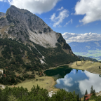
Hard, really really really hard. The longest climb I have ever done and the longest that you can find on Kinomap: Cime de la Bonette at 2802 m starting just north of Nice at an altitude of 200 m. A super long climb of 77 km (!!!), with 2600 m elevation, split in 2 videos, because I needed to stop half-way to get energized (eating flies was not sufficient). Good luck and enjoy!!
Part 1 (and if you managed the climb enjoy the downhill Part 1 and downhill Part 2)
Interested in doing other huge climbs, see long epic climbs
(PS: 'likes' and 'comments' on the video are much appreciated. Please send comments on the functioning of the app to the User Support)
For more than 1000 scenic videos all over Europe, see my other videos by Gonvil and Playlists by Gonvil.
 Strava segments
Portions of this video are actual Strava segments


| Pos. | Username | Chrono | Date |
|---|---|---|---|
| 1 | 00:46:05 | 1/19/2024 | |
| 2 | 00:46:20 | 11/7/2023 | |
| 3 | 00:50:21 | 2/12/2022 | |
| 4 | 00:50:35 | 3/14/2025 | |
| 5 | 00:51:38 | 12/2/2021 |

You can try our application fully and for free and challenge community members.
iOS Android No access to Google Play? Download the APK nowGet all features and videos for only $11.99/month
Subscribe nowYou will probably like...

15.59 mi | 01:12:32

12.442 mi | 00:45:22

11.534 mi | 00:42:52

12.388 mi | 00:50:31

10.63 mi | 00:37:46

12.428 mi | 00:40:43

15.128 mi | 00:55:57

15.403 mi | 00:52:52

10.433 mi | 00:44:11

12.082 mi | 00:52:01

9.218 mi | 00:35:00

11.475 mi | 00:58:04


 French
 German
 United States
 Chinese
 Spanish
 Italian
 Dutch
Dutch