
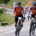
Cl 8 # 21 - 154, Zipaquirá, Cundinamarca, Colombia
Pacho-Zipaquirá, Zipaquirá, Cundinamarca, Colombia
 Strava segments
Portions of this video are actual Strava segments


| Pos. | Username | Chrono | Date |
|---|---|---|---|
| 1 | 00:35:47 | 8/19/2022 | |
| 2 | 00:41:18 | 10/19/2022 | |
| 3 | 00:47:38 | 8/18/2022 | |
| 4 | 00:51:41 | 8/20/2022 | |
| 5 | 00:58:42 | 1/20/2025 |

You can try our application fully and for free and challenge community members.
iOS Android No access to Google Play? Download the APK nowGet all features and videos for only $11.99/month
Subscribe nowYou will probably like...

7.794 mi | 00:37:37

14.175 mi | 01:03:03

7.89 mi | 00:44:33

6.123 mi | 00:19:31

14.298 mi | 00:53:07

7.147 mi | 00:29:44

6.987 mi | 00:30:09

10.433 mi | 00:44:11

5.892 mi | 00:24:01

8.129 mi | 00:44:32

9.218 mi | 00:35:00

11.475 mi | 00:58:04


 French
 German
 United States
 Chinese
 Spanish
 Italian
 Dutch
Dutch