
24 Rue de la Libération, 67220 Saint-Martin, France
110 Foret de Chirgoutte, 67130 Bellefosse, France
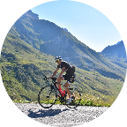
A la découverte du massif Vosgien jusqu'au col de la Charbonnière Je vous emmène sur ce parcours de semi montagne jusqu'au col de la Charbonnière situé à 960m d'altitude. Discovering the Vosges mountains to the Charbonnière pass. I take you on this middle mountain track to the Charbonnière pass located at 960m altitude.
 Strava segments
Portions of this video are actual Strava segments


| Pos. | Username | Chrono | Date |
|---|---|---|---|
| 1 | 00:20:32 | 1/13/2023 | |
| 2 | 00:23:00 | 12/31/2021 | |
| 3 | 00:23:48 | 5/26/2023 | |
| 4 | 00:25:35 | 12/26/2021 | |
| 5 | 00:25:39 | 9/18/2020 |

You can try our application fully and for free and challenge community members.
iOS Android No access to Google Play? Download the APK nowGet all features and videos for only $11.99/month
Subscribe nowYou will probably like...

7.147 mi | 00:29:44

5.892 mi | 00:24:01

7.665 mi | 00:45:19

9.218 mi | 00:35:00

8.163 mi | 00:26:38

7.356 mi | 00:35:06

6.747 mi | 00:32:52

5.802 mi | 00:28:59

7.743 mi | 00:29:23

8.599 mi | 00:35:29

4.627 mi | 00:24:09

6.211 mi | 00:39:37


 French
 German
 United States
 Chinese
 Spanish
 Italian
 Dutch
Dutch