
D157, 30750 Saint-Sauveur-Camprieu, France
L'Aigoual, 30570 Valleraugue, France
The Rider VI - Camprieu - Mont Aigoual
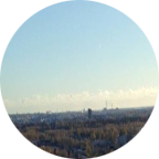
Climbing. Hands on the bars, my wrists in front of me. They’re wet. Mont Aigoual is almost the highest mountain in the Cévennes, but height doesn’t mean everything: in Holland there are hills steeper than Mont Ventoux.
Mont Aigoual is tough, but regular. It’s made up of three parts. First, three kilometers to the Col de la Sereyrède, then three kilometers to the ski area at the Col de Pra Peirot, then two more to the summit of Mont Aigoual itself.
From the book THE RIDER by Tim Krabbé (a must read book for every cyclist)
This video covers the sixth part of The Tour de Mont Aigoual where the riders leaving Camprieu and climbing tot the summit of Mont Aigoual as described in the book THE RIDER.
More rides of the book The Rider in this playlist or Check my other video's
 Strava segments
Portions of this video are actual Strava segments


| Pos. | Username | Chrono | Date |
|---|---|---|---|
| 1 | 00:23:09 | 2/25/2022 | |
| 2 | 00:25:10 | 5/4/2020 | |
| 3 | 00:25:40 | 1/28/2023 | |
| 4 | 00:27:17 | 3/16/2021 | |
| 5 | 00:29:04 | 9/10/2021 |

You can try our application fully and for free and challenge community members.
iOS Android No access to Google Play? Download the APK nowGet all features and videos for only $11.99/month
Subscribe nowYou will probably like...

12.442 mi | 00:45:22

7.89 mi | 00:44:33

12.388 mi | 00:50:31

10.63 mi | 00:37:46

12.428 mi | 00:40:43

7.147 mi | 00:29:44

10.433 mi | 00:44:11

5.892 mi | 00:24:01

7.665 mi | 00:45:19

9.218 mi | 00:35:00

6.861 mi | 00:27:33

8.163 mi | 00:26:38


 French
 English
 German
 Chinese
 Spanish
 Italian
 Dutch
Dutch