
18 Rue des Communes de France, 06660 Saint-Étienne-de-Tinée, France
455 Rte de la Tinée, 06710 Tournefort, France
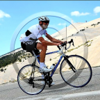
Don't miss this!!! The downhill (in 2 parts) on the highest paved road in France with spectacular views on the mountains. Perfect after a tough day for a relaxed workout while admiring the scenery. It is a very very long downhill, almost reaching Nice. Enjoy!!
For the first part see Bonette downhill - Part 1
See other downhills at downhills by Gonvil
(PS: 'likes' and 'comments' on the video are much appreciated. Please send comments on the functioning of the app to the User Support)
For more than 1000 scenic videos all over Europe, see my other videos by Gonvil and Playlists by Gonvil.
 Strava segments
Portions of this video are actual Strava segments


| Pos. | Username | Chrono | Date |
|---|---|---|---|
| 1 | 00:32:14 | 6/2/2024 | |
| 2 | 00:47:36 | 5/24/2024 | |
| 3 | 00:51:49 | 5/22/2024 | |
| 4 | 00:53:15 | 1/30/2022 | |
| 5 | 00:53:37 | 1/30/2022 |

You can try our application fully and for free and challenge community members.
iOS Android No access to Google Play? Download the APK nowGet all features and videos for only $11.99/month
Subscribe nowYou will probably like...

19.116 mi | 01:13:12

25.786 mi | 01:36:22

20.089 mi | 01:00:00
![[LONG] Kielce - Bolmin - Kielce (Poland)🚴🏘️🌲⛰️](https://dtn44hfc1xtr4.cloudfront.net/z/8/z8hrj6_320x240.jpg?Expires=1758145740&Signature=VYhL5Wrb7LzllwfRgb86vojHlYFmXm-wDrXyzYTxWyk4jJOYNqVNlzo6-KV98nz8MloVcG8zDJvQsN~kFI45fDFbpQlcqC4asitOG2HmDCfm6nkTg6ejboV3R6hMFifBM~BTtQdfOaAxwBv~2LEHeL~3l0zpc~jocUyw2OK1iavKFhfxl8zg8kMkPN2xq-BT0eEaK1ejlnWG245dn6SqanRF2CibYhusCjBKWzVyy873R5nglhS-V915ydWsVlC8wffIaMAuO7o-hw8E-QDnD8CputdrEZxoa6yqwPS92Yvx8DIDztaPrdLFI8vAjARALfk67wqCbEsYGwbWUXS8mw__&Key-Pair-Id=APKAIAOH4YUSYMI7SPBA)
38.334 mi | 02:03:29

15.97 mi | 01:05:11

41.231 mi | 01:50:32

20.357 mi | 01:06:14

46.733 mi | 03:12:13

19.581 mi | 01:58:17

40.175 mi | 02:29:13

23.373 mi | 01:12:35

15.65 mi | 01:00:13


 French
 English
 German
 Chinese
 Spanish
 Italian
 Dutch
Dutch